GEOFON real-time earthquake monitoring - how does it work?
Every day there are tens of earthquakes causing small to severe ground shaking. Only a few of these can be felt immediately by people in the vicinity of the epicenter. Many more earthquakes can be located only using a sensitive, global, network of instruments.
Here we describe how earthquakes are located by our instruments and quantified here at GEOFON.
Global earthquake monitoring
When an earthquake ruptures it radiates seismic energy in the form of seismic waves. These waves propagate away from the earthquake source at wave speeds that depend on the mechanical properties of the rocks that the seismic waves travel through. If the earthquake and hence the energy of the seismic waves is large enough, the waves may be registered as a signal at a distant seismic sensor.
Since earthquake waves travel at a finite speed the signals are recorded at seismic stations with a delay, which depends on the wave type and the path the wave has travelled. Compressional waves, so-called P waves, are the fastest and travel with speeds ranging from about 6 km/s in the Earth's crust to up to about 14 km/s in the mantle. P waves are the signals most commonly used in earthquake location.
The distribution of the seismic wave speeds is relatively well known for most parts of the Earth. Allowing a prediction of the arrival time for any point on Earth for any earthquake hypocenter and time. By measuring the arrival times at many stations and comparing these with the times predicted for certain hypocenter locations and times, the latter can be estimated quite accurately. This is the principle of earthquake location.
Using sensitive modern digital broadband seismometers deployed at seismic stations, recording the ground motion continuously, seismic waves radiated from earthquakes can be detect anywhere on Earth, provided the earthquake signal amplitude is sufficiently above the background noise. As a rule of thumb, earthquakes above a magnitude of about 5, sometimes a bit less, can be recorded at quiet sites world-wide. Smaller earthquakes are normally recorded at shorter distances only. For instance a magnitude 3 earthquake in Central Europe is usually well recorded up to distances of about 100-200 km.
Data acquisition
Before the arrival times of seismic phases can be measured, the waveform data must reach the GEOFON data center at Potsdam. Nowadays, real-time data telemetry is standard for permanent seismic stations. Often stations are installed in very remote areas, where there is no other means than satellite connection. In other places, permanent internet connections, or even dial-up lines, can be used. To keep operating costs to a minimum, GEOFON stations are connected to the GEOFON data center by the technology that provides the best reliablility at the lowest possible cost. At stations within Europe where the infrastucture is excellent, costly satellite telemetry can mostly be avoided. In contrast, in the Indian Ocean region, VSAT is often the only option, not only because of the lack of land-based alternatives, but also because data must remain available immediately after major earthquakes, when Internet connections or mobile phone lines may have failed. Often a combination of VSAT and terrestrial Internet connections are used: VSAT connects the remote station site to a regional satellite hub, from where the data are streamed through terrestrial Internet connections to Potsdam. A protocol called SeedLink, developed by our group in 2001, is used to cope with the diversity of possible data transport links. Advanced: This protocol has become a de facto standard for reliable data transmission from the stations to the data centers but also amongst data centers. Data transmission is very fast, with delays typically in the range of 5-30 seconds.
Virtual network
In addition to the approximately 80 stations currently active in its own network, GEOFON acquires data from partner networks, which are included in our processing. This increases the number of stations available in real time to form a virtual network of over 1000 stations and ensures good global coverage with stations. Even at times when some networks are unavailable due to technical problems, there are always enough stations providing data to allow a reliable earthquake monitoring.
Automated analysis in real time
Once the data arrive at the GEOFON data center they are analyzed in real time. At the same time, they are archived permanently and made available to the scientific community. At the first stage, phase [Link: IASPEI (2001)? MSOP (1979)?] arrivals must be detected and timed. Advanced: Usually phase arrivals are characterized by a rather sudden increase in amplitude within a relatively narrow frequency band at around 1 Hz, where the signal-to-noise ratio is usually favorable to observe signals from earthquakes thousands of kilometers away. By comparing the short-term average amplitude to the long-term average amplitude, sudden amplitude increases can be detected quite reliably. The time of the onset of the amplitude increase is then taken as the arrival time of the seismic phase. This procedure is normally referred to as "phase picking". P waves are the fastest seismic waves and usually provide the best defined onset times, so normally the vertical component of ground motion is used for phase picking, where the P wave can be observed best. The continuously flowing waveform data produces frequent phase picks with sometimes hundreds of picks per hour [per stream?]. The vast majority of these picks do not correspond to seismic phase onsets i.e. actual earthquakes, but represent noise generated by human activities ( e.g., mining, traffic) or weather phenomena (e.g., thunderstorms). It is important to prevent these from being misinterpreted as seismic phase onsets. The software that analyses the phase picks in real time has to recognize picks corresponding to the same event while at the same time it has to keep the wrong picks out of the solution. The more picks are available for a given seismic event, the better this distinction will work, because questionable or inconsistent picks can be identified more easily.
Internally an earthquake is often located within a few minutes of its occurrence. Much of the delay is due to the time for seismic waves to reach enough stations to form a rough initial location. As more picks are received from stations further away from the epicenter, the initial location gets refined. In parallel to locating the earthquake, amplitudes are measured, which are then used to compute the magnitude of the event. Once a certain publication threshold is reached, usually defined by the number of picks contributing to the location, the information on the earthquake is published. As the automatic analysis continues, updated solutions - both in terms of location and magnitude - are provided immediately on the GEOFON earthquake bulletin web site and the RSS feed. E-mail is normally sent only once for an event, immediately after the publication threshold is reached. (You can sign up for e-mail alerts.) The GEOFON publication criteria are chosen to ensure a reasonable quality of the solution, but it is recommended to check the GEOFON earthquake bulletin website for the latest updates.
Manual revision
Up to this point in the processing chain, the analysis and publication is fully automatic. This ensures that within a short time after an important earthquake, the main parameters epicenter location, depth and magnitude are made available on the GEOFON website day and night, 7 days a week. Automatic solutions, however, are subject to uncertainties. One parameter which is often difficult to determine with good accuracy is the focal depth. Especially for shallow earthquakes where a difference of 10 km in depth might make a big difference in terms of expected damage. Advanced: The depth uncertainty is related to the geometry of the waves leaving the source. To allow a good depth estimate, it is important to have data from stations close to the epicenter. This is often not the case, especially in remote regions, or due to restrictive data policies. As an alternative to using data from nearby stations, it is possible to constrain the source depth using so-called depth phases. These are waves initially travelling upwards from the hypocenter and then being reflected at the Earth's surface, resulting in a seismogram in which both the direct and the reflected phase are visible. From the time difference between the two phases, the depth can be estimated quite accurately. Unfortunately these depth phases require observations from at least 3000 km away from the epicentre, and even there depth phases cannot always be identified. Furthermore, depth phases of shallow events follow the direct waves very closely and it requires an experienced analyst to distinguish them reliably. This unfortunately prevents the use of depth phases in automatic processing. At GEOFON depth phases are hand picked if present, improving the depth accuracy during a manual revision of an event. Manually revised events are marked with a green M in the event list.
[Mention: we do not run a 24-hour operation.]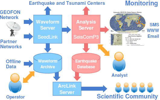
Left: Schematic view of the data flow at the GEOFON data center. Blue arrows represent the flow of seismic waveform data, whereas red arrows represent derived parametric data. Human interaction with the mainly automatic system is represented by orange arrows.
Further reading
- Bormann, P. (Ed.) (2012). New Manual of Seismological Observatory Practice (NMSOP-2), IASPEI, GFZ German Research Centre for Geosciences, Potsdam; http://nmsop.gfz-potsdam.de; DOI: 10.2312/GFZ.NMSOP-2 urn:nbn:de:kobv:b103-NMSOP-2